The Île-de-France Metropolis
in Agriculture

After decades of division between cities and agriculture within the framework of sectoral development policies[1], at a time when urgent environmental action is needed, the recurrent crises of urban and agricultural systems compel us to rethink the relationship between farmland and urban society. As dispersed metropolises[2] are absorbing increasingly larger agricultural areas—75% of France’s agricultural potential according to the 2010 agricultural survey and the INSEE statistical office’s zoning of urban areas—large cities which “do not self-produce the food that sustains them”[3] are now being referred to as “naked cities”[4] or “hungry cities,” “new combinations that do not preclude them from conflicts and contradictions but that bind them ever more strongly”[5] are being identified everywhere on the path towards agri-urban development.

◀︎  Back

Market gardening, Herr streat, Paris 15th, around 1900. © Union Photographique Française / Musée Carnavalet - History of Paris / Roger-Viollet

Monique Poulot
Doctor of Geography

February 26, 2022
20 min.
Shrinking cities, such as Detroit[6], are excellent illustrations of this trend, but it is equally present in more prosperous North American ones, such as Montréal, Toronto, and New York, as well as in Europe, as was revealed by the last World Expo, “Feeding the Planet, Energy for Life!,” hosted by Milan in 2015. The Île-de-France metropolis displays the same trajectory, and the stormy relationship it has with its agriculture and, more generally, with land, provides a new reading of economic, political, and social change over the long term. This region, which is a remarkable site of hydrological convergence among loamy tableland, bears in its center a two-thousand-year-old city that has experienced galloping growth since the Second World War, to the point that it has become continental Europe’s largest conurbation, now boasting 12 million inhabitants. This growth, which was undergone as the age of the automobile was triumphing, caused an unprecedented sprawl of buildings and infrastructure, first in the suburbs, and then in the more remote periphery, the so-called “commuter belt” (couronne périurbaine in French)[7], to the detriment of agricultural areas, which were considered simply as land reserves. Urban planning, which was carried out by the government, was then approached solely from the urban perspective, particularly since, concurrently, the French agricultural productivity revolution supported by the Common Agricultural Policy (CAP) and the transforming and modernizing of food supply chains viewed from a global perspective, had caused the Île-de-France’s market-garden belt to all but disappear, replaced by largely export-oriented cereal-based farming systems. Agriculture’s comeback in urban environments over the past two decades, under the umbrella term of “urban agriculture”[8] but taking many different forms, is clear evidence of a new era as it draws from other approaches to planning and in novel demands in terms of agriculture and food, which bring into play new territorial meshes, drawing together the city and the countryside around the notion of proximity among others.


From an Agriculture at the Service of the City to Urban Preeminence

The Triumphant City

Throughout the centuries, the French capital has largely drawn its strength and its development opportunities from the surrounding countryside[9], and the pages of Émile Zola’s novel Le Ventre de Paris are a striking echo of this. The urban–rural synergy is first reflected in urban financial flows directed at land, whether speculative or investments, and have often played a decisive role in terms of agricultural innovation (taking over new lands, adopting modern technologies, better farming practices, and so on), but also in investments in holiday homes and leisure, as was the case with the follies of the Brie region. It is also reflected in the development of a form of agriculture for the city that aimed at supplying it with cereals and fresh produce, matching the food diets of those times. Shielded since the sixteenth century by commercial privileges then granted by the crown, which was concerned about the food supply of urban dwellers, this form of agriculture benefited from technical progress often born of aristocratic parks[10]. Dairy, vegetable, and fruit production, among others, have forged a true body of “specialist” farmers cultivating crops for the city—the market gardener being their key figure—promoters of innovative methods prone to increasing added value (sowing and planting under cover, landspreading night soil) and organized in specific producer groups[11]. This form of agriculture reached its heyday towards the end of the nineteenth century, at a time when more than 50,000 hectares of farmland were devoted to it[12], preferably located in valleys, on well-exposed slopes, and forming rings of special crops around the city, cereals being relegated to the peripheral plateaux. This concentric arrangement was formalized by the German gentleman farmer Johann Heinrich von Thünen during the nineteenth century, based on differences in land rent for various crops[13].

But, in the early twentieth century, this synergy experienced rapid change under the double transformation—both agricultural and urban—and the development of efficient and rapid means of communication. On the one hand, polyculture, which had been the norm to that point, started being phased out by regional specializations based on climatic and topographical conditions, as fruit, vegetable, and flower cultivation become the appanage of southern France while the loamy plateaux of the Parisian Basin focused increasingly on cereal crops thanks to the emergence of mechanization, transport ensuring ulterior redistribution. On the other hand, the urbanization of Île-de-France crept in sooner in the valleys, especially along the railway lines, colonizing the fragmentary smallholders plots of the ever decreasing market-garden belt. Though World War 2 and food shortages led to land being brought back into cultivation, including within the very heart of the French capital, as in the Luxembourg Gardens, the trend bounced back after the war and then picked up speed. Special crops accounted for only 28,000 hectares in 1955, mostly concentrated in the Seine-et-Oise département, along the Seine valley.

Postcard, Barbizon, the entrance through chailly, n.d. © Pavillon de l'Arsenal Postcard, Barbizon, the entrance through chailly, n.d. © Pavillon de l'Arsenal
Postcard, Ivry-sur-Seine, Charron Fils horticultural establishment, one of the Phoenix greenhouse, circa 1909. © Pavillon de l'Arsenal Postcard, Ivry-sur-Seine, Charron Fils horticultural establishment, one of the Phoenix greenhouse, circa 1909. © Pavillon de l'Arsenal
Postcard, Orly, gardening school, training for adolescents, culture under bells, circa 1908 (lower right). © Pavilion de l'Arsenal Postcard, Orly, gardening school, training for adolescents, culture under bells, circa 1908 (lower right). © Pavilion de l'Arsenal
Postcard, Arccueil, market gardening, circa 1914. © Pavillon de l'Arsenal Postcard, Arccueil, market gardening, circa 1914. © Pavillon de l'Arsenal
The second half of the twentieth century confirmed the logic of separation between city and agriculture, giving priority to the expansion of the French capital. The various development schemes, conducted by the central government up until the 1990s, were dominated by the issue of housing and urban expansion, following a principle of gradual absorption of the countryside and its activities. The SDAU (Master Plan for Urban Planning and Development) of 1965 was the most significant, projecting a two-percent growth rate for the Parisian conurbation (twice that of the rest of the country) and put forward an urban form that is still current: building along two tangential axes running parallel courses along to the north and south sides of the existing built-up area, and strengthened by the creation of five new towns on the plateaux. This urban development scheme was designed by “technocratic urban planners,”[14] and the lands to be urbanized were naturally taken out of the existing farmland. In this vision of the absolute primacy of the city, only the woodlands were preserved in order to serve as recreational spaces for city dwellers, as well as a few green spaces thanks to the “sensitive natural area” procedure managed by the départements. Farmland was depicted as blank in the legends of the SDAU maps and existed solely as a cheap land reserve: they were the negative image of the city and only occurred in contact with the conurbation to provide some airing in the urban fabric. From 1968 to 1975, approximately 6,500 hectares of farmland were absorbed annually for housing developments, designated development areas, and infrastructure use. Though the market-garden belt was the most impacted, some cereal farms disappeared in turn when the urbanization of the plateaux began, as in the Vexin with the new city of Cergy-Pontoise, in the priority urbanization zones (ZUP), or under the runways of Roissy Airport. The farming profession received some compensation, including several agricultural allotments for special corps further away from the urban front (in Saint-Rémy-l’Honoré, Mandres-les-Roses, and so on), but mostly focused on upholding the productivist approaches promoted by the CAP and the agricultural framework laws of the 1960s, which find fertile ground in the large-scale cereal farming operations of Île-de-France. Covered by land reparcelling operations starting towards the end of the nineteenth century, they were provided with abundant urban and agricultural capital, equipped to address the requirements of the agrifood industries and shift towards specialized production areas geared towards the national and/or global market, likely to be produced at lower costs. Given this configuration, the physical proximity to the city was perceived by farms as creating difficulties (lack of ease of movement of farm vehicles, physical insecurity, insecure land tenure, damage and theft in the cultivated plots), resulting in higher production costs and to distancing or relocation strategies, further confirming the city–agriculture divide.

In 1900, the proximity between agriculture and collective buildings made it possible to feed city dwellers and organize the recycling of their waste. In the aftermath of the Great War (First World War) the city was organized by functional sectors with a view to military reconstruction. Even today, the traditional city footprints and the mixed fabrics concentrating collective life are separated from cultures by a set of monofunctional zones: large housing estates, housing estates and economic activity zones. © DR
The urban projects of the 1970s, which focused on reinforcing the international stature of the French capital, paid little attention to agricultural issues. Some minor adjustments occurred for landscape considerations, as in the Master Plan of Urban Planning and Development of Île-de-France (SDAURIF) of 1976, which was voted through when the Paris region became Île-de-France and the Regional Council took over the environmental prerogative. The notions of “green urban grids” (trames vertes) and “natural green belt zones” (zones naturelles d’équilibre) (1972) were thus defended by regional representatives who were more tuned in to the concerns of their constituencies in terms of the living environment and concerned with territorial regional development. The 1976 creation of AEV, the Green Spaces Agency (Agence des Espaces Verts), dedicated to purchasing woodlands and green spaces to contain urbanization and placed under the authority of the Region president after the 1982 decentralization laws, figures as a good benchmark of the region’s positioning. The laying-out of the very first natural regional park, in the Haute-Vallée de Chevreuse in 1985, as well as the Green Belt in 1987—circling Paris at a ten-to-thirty kilometer distance from Notre-Dame de Paris—follow the same line: regional representatives and residents joined together in powerful environmental groups undertake to promote controlled urbanization, incorporating breathing spaces that can bring an improved quality of life and landscape amenities to the city’s population. Another urban form with a stronger foothold in the physical territory of Île-de-France, working around the alternating valleys and plateaux and the network of state-owned forests, then emerges, as a counterpoint to the Plan Delouvrier, the two figures that nevertheless sometimes follow concentric layouts.


From Landscape Grievances to Agriurban System

The Ruralization of the City and the Urbanization of Agriculture

Recent developments over the past twenty years, portend a reversal that is supported by residents in search of meaning and made necessary by the repeated crises of both agricultural productivism and large urban institutions that are ever more spread out and congested, ultimately jeopardizing our food and health. The dominant paradigm of sustainable development that has been taking over the public sphere since the start of the 1990s provides a framework that could bring together visions of planning that were hitherto irreconcilable. Indeed, this formula allows for the construction of figures that include not only the naturalistic dimension of a place, but also its economic and social aspects (taking into account the practices and representations of the various stakeholders and possible conflicts), thus fostering a sense of ownership. The goal is to move towards local, endogenous development, both attached to a balanced distribution of in-situ resources between stakeholders and attentive to the repositioning of local approaches within a global perspective, as if each site were a “common good” for the whole of humanity. The return of agriculture in the city is perfectly in line with this vision: it is now acknowledged as multifunctional since the new CAP of 1992 and the agricultural framework law of 1999, supplying the city with not only food products through reinvented short supply chains[15], but also environmental, recreational, educational, and heritage goods, and is now firmly established as a component of the making of the sustainable city[16]. The latest European and French programming documents (as well as the 2016 Law for the future of agriculture, food, and the forest) go so far as to promote organic farming and agroecology, which have become new agricultural models that are described as either post-productivist or alternative. At the same time, since 2011, France’s adoption of the National Food Program underlines the importance of short supply chains and calls for relocating agriculture—quality agriculture—next to cities. The Île-de-France region has engaged in a regional roll-out of these documents, with a Regional Sustainable Agriculture Plan (in 2012) and a Sustainable Food Plan (in 2015), both of which affirm the necessary restoration of the place of agriculture in cities.

The aggiornamento nevertheless remains challenging given how much the ways of developing the city and the agricultural countryside have diverged, and how strongly economic constraints are continuing to weigh on the situation. Regardless, some forms of redevelopment of agricultural lands can be spotted both in the center—gardens and projects of tower farms, as in Romainville—and in the periphery of the Parisian conurbation, as can be seen in most cities today[17]. Productions and constructions exist side by side, as farming operations supply markets or city dwellers directly through new forms of short supply chains, with producers that self-identify as professionals or hobbyists. The desire for agriculture thus materializes within the city and leads to its ruralization. To a certain extent, as was the case with the mountains and its “sublime horrors,” and then with the “territory of the void” of the seaside[18], sublimated and given value to first by the affluent classes and then by the whole population with the advent of mass leisure, agricultural spaces are in the process of being discovered, appreciated, and included in collective representations as strategic areas that must be preserved and valued. They thus appear as one of the disappearing borders in this movement towards the taming and publicization of places, identified by historians from the eighteenth century onwards. This desire for agriculture is paradoxically rooted in the periurbanization that has transformed the Île-de-France metropolis for the past thirty years or so: all surveys that are conducted indeed reveal how attached the residents of periurban areas are to rural forms—from the fields to the meadows, and the low density—all serve as guarantors of a better quality of life[19]. Overvalued in the rhetoric of local residents and with acknowledged relevance, agriculture provides a set of references, both explicit and implicit, to the natural characters of our living spaces, to a certain connivance with the environment, to a way of life with firm local roots. The desired agriculture is urged to reconnect with proximity, cutting loose of the separation logics that prevailed in the context of productivist agriculture. Also on the agenda is the implementation of diversification strategies to replace the extreme specialization that had been dictated by the quest for the lowest possible production costs, and more broadly, the reconciling of economic and territorial considerations, economic and landscape considerations, or even heritage, economical, and social considerations. Several types of agriculture thus attract a wide consensus: first and foremost a local, quality agriculture to feed the city itself, with marketing channels ranging from farm-gate sales and the AMAP farm basket scheme to open-air markets; it is also an agriculture that is open to the development of forms of reception (pick-your-own operations, educational farms, and so on); furthermore, it is a service agriculture (providing technical services as well as social services, working on better integrating vulnerable sectors of society); finally, it is an agriculture contributing to the environment (upkeep of certain spaces such as the areas around airports, ponds, and swales to mitigate flood risks, and so on). In this new taming between agriculture and local residents, gardens, which had been endowed only with a purely recreational value during the first ages of periurbanization, are now shifting towards a value in productive use; helping (re)create bonds between a living environment and its human inhabitants, it is conducive to a reciprocal acculturation between practices and urban and rural socializations.

In 2010, Nadine Lahoud created Veni Verdi, an association that installs gardens in schools. An action that educates children from an early age to the protection of our environment. © Sylvain Gouraud, in Capital Agricole In 2010, Nadine Lahoud created Veni Verdi, an association that installs gardens in schools. An action that educates children from an early age to the protection of our environment. © Sylvain Gouraud, in Capital Agricole
Though this desire for agriculture is genuine—as demonstrated by the success of open farms and pick-your-own operations, the AMAP farm basket scheme (there are now more than three hundred though the first one was created only in 2003)[20], and the waiting list for shared or community gardens—the urban project is correspondingly becoming greener and above all agricultural. The Île-de-France Development Master Plan for 1994 (SDRIF 1994) had already involved rebuilding the city on itself, giving special consideration the Green Belt and mandating AEV to take action over farmland threatened by urbanization through the use of Périmètres régionaux d'intervention foncière, literally “Perimeters for Regional Intervention on Land Ownership,” with the possibility of pre-empting farmland. But it is truly the Master Plan for 2012 (SDRIF 2012), which was the first one to be carried by the Île-de-France region alone following the terms of decentralization, that contemplates the necessary synergy between agriculture and the city. To the initial project focusing on three pillars—“i) developing economic excellence by advocating ii) reducing territorial, social, and environmental inequalities, and iii) promoting an urban organization that addresses issues related to climate change and the energy transition—was appended the “food challenge,” “because feeding the 11.5 million residents of Île-de-France directly questions ... the policies concerning the management and valorization of agricultural spaces and agrifood value chains.”[21] Thus, for the very first time, a general plan from the Île-de-France region strongly underlines the specificity of agricultural spaces as a “key component of regional development”[22] and grants a new level of appreciation to agriculture, first for its “considerable production,” then for its “contribution to the living environment,”[23] and finally for its “role in terms of ecological functionality,”[24] whereas the previous documents only valued agriculture in so far as “the living environment” was concerned.

AEV’s recent operations, which increasingly involve agricultural land, embody these new directions: in 2016, farmland represented 45% of the acreage of the fifty-five Perimeters for Regional Intervention on Land Ownership, and 2,244 hectares of Utilized Agricultural Area (UAA) were purchased[25] by the Île-de-France region and leased on a long-term basis to a hundred and twenty-five farms. This newly constructed property portfolio, though amounting to only 0.3% of the UAA of Île-de-France, demonstrates the shift in the region’s policy, which aims to “sustain and support agricultural production and its branches ... by providing greater clarity to farmers.[26]” Its recommendations are based on a regional food balance index—the estimated production–consumption ratio–that averaged 1.7% for dairy, 2% for poultry, 3.9% for fruit, 21.8% for vegetables (with the exception of lettuce, at 158%), and 120% for bread-making wheat[27]. Such an imbalance calls for “shifting certain agricultural areas towards local food production …[focusing] in particular towards garden market production, in order to foster short food supply chains[28]”. Far from opting for a heritage garden-market belt to be preserved, the Île-de-France region is aiming for a belt that must be extended and made workable by active interventions under its direction, through the safeguarding of land, the maintaining or restoring of upstream and downstream agrifood industries, and supporting new marketing channels.

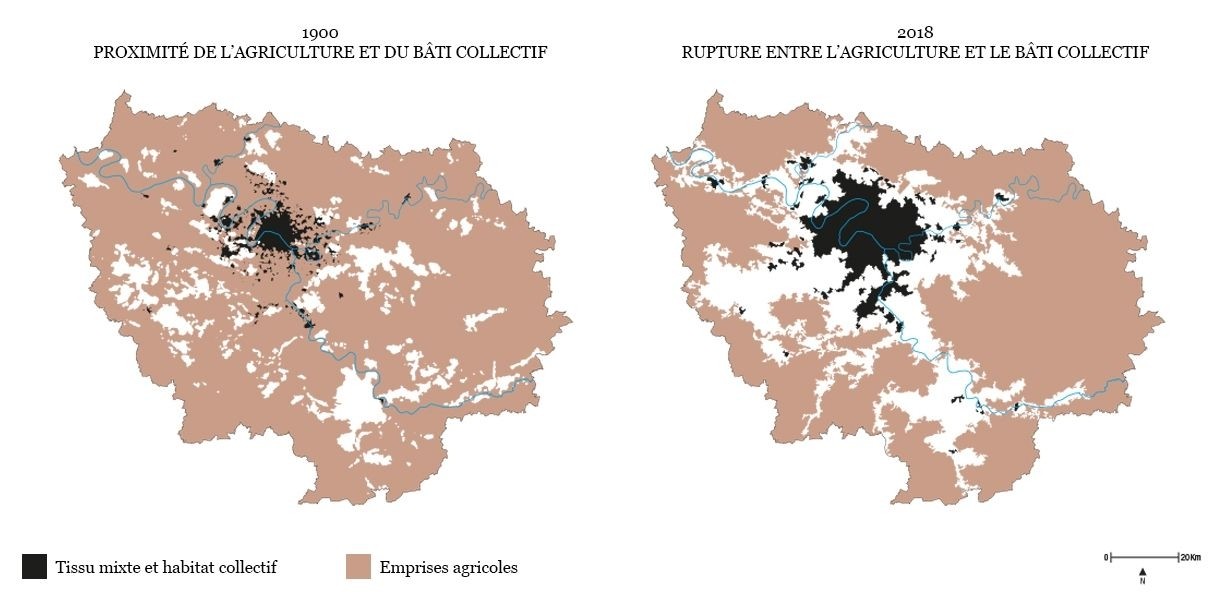
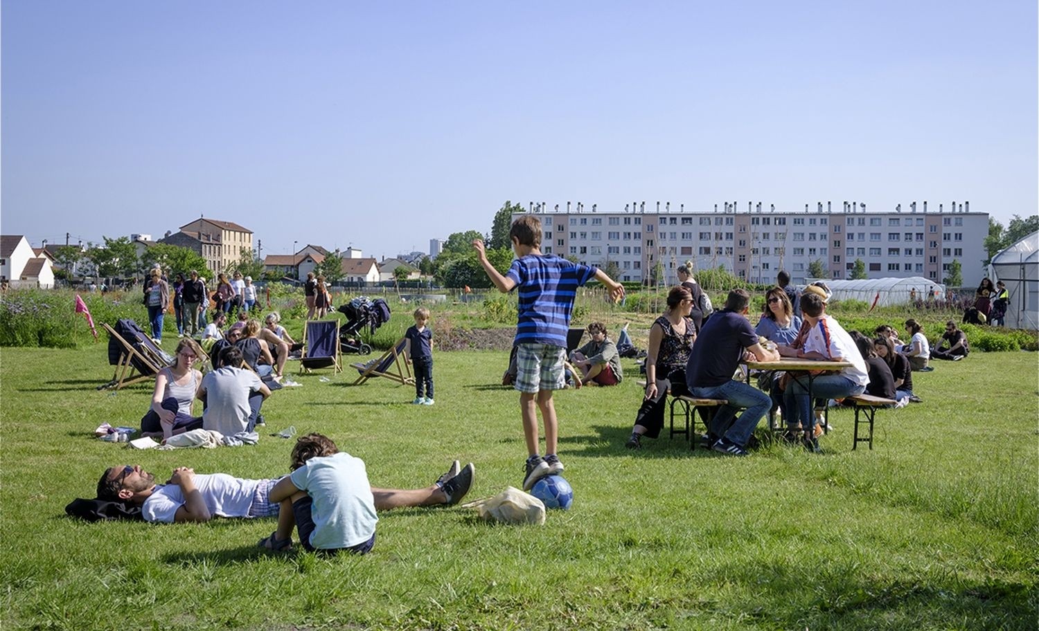
The desired symbiosis makes it very clear that the “divide between dense city and periurban, or even rural, spaces” is to be overcome, given that “large agricultural areas … contribute towards urban intensity as well as remarkable landscape openings.[29]” To the now standard city-as-nature[30] trope is now shifting towards the city-as-countryside or even the city-as-farmland, where agricultural land and built-up areas and form together part of the spread-out city[31]. Crucially, various territories are expressly identified as anchor points for future agriurban constructions: these are first and foremost the five natural regional parks (two new ones are in the project stage), but also the unique formula of the agriurban[32] territories along the Green Belt. The project for the park located in Val d’Orge, on the former air base of Brétigny (in the Essonne département), gives a comprehensive summary of the approach :


 The agricultural purpose of the site must be upheld and enhanced. Its central portion will be dedicated to organic market gardening over an area of 90 hectares. An urban front will split the former air base into two areas: to the north and west, land reserves for future urban development and open spaces to be preserved to the south, partly used for agrifood research. The eco-site project must ensure that a strategic project is set out … limiting urbanization and fostering its integration in the landscape [33]


These proposals highlight the logic of sharing spaces and designates domains for the transactions between stakeholders looking for a collective agriculture-based project, from the drawing-up of the territorial unit to the cultivation specifications and the ways the built environment and agriculture will come into contact.
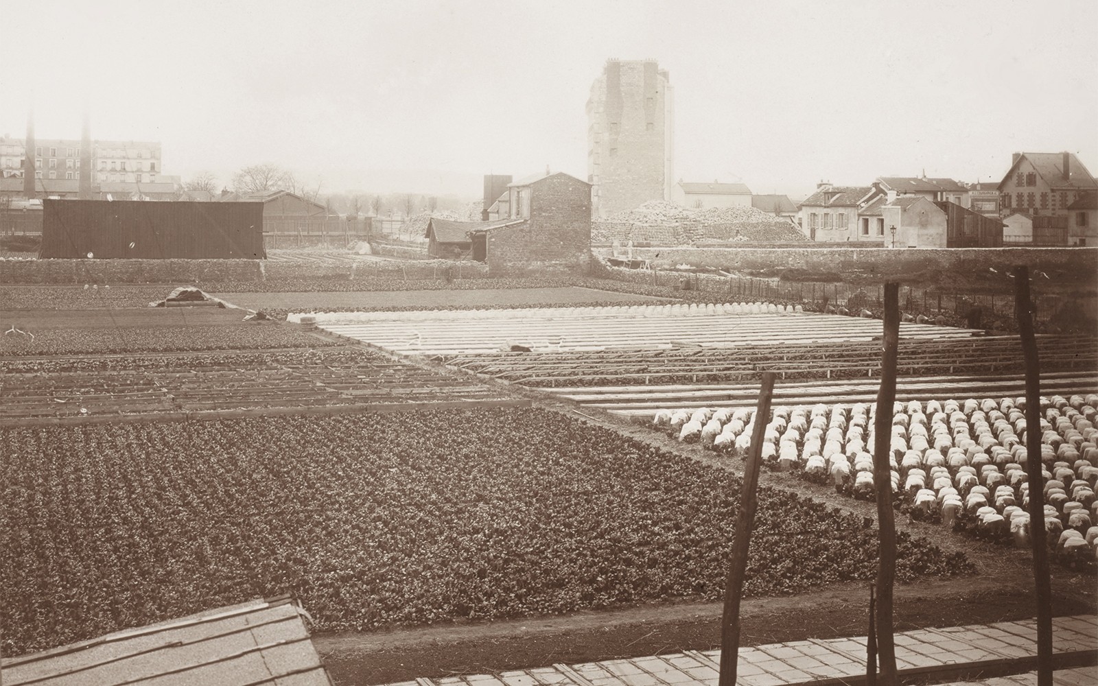
Within this “dance duet between the city and agriculture” that has been identified as a long-term trend, the various types of agricultural countryside around cities—for nourishment (produce and rents) and for holiday homes during the nineteenth century, followed by those that came under urbanization and globalization during the twentieth century—have often been on the defense, continually pushed back, replaced by mass retail. The urban project, entirely focused on housing and infrastructure, and formalizing the city’s role as a hub, ignored them, and sometimes even actively fought against them in terms of competition for land. Periurbanization even seemed to lead to their disappearance given to what extent urban sprawl implied an entanglement of forms that made it almost impossible to continue pursuing agricultural activities. Their fading away paralleled the integration in the productivist agricultural project which favored specialized production areas, structured around large operations and agrifood industries that are often difficult to reconcile with urban environments given their size and the nuisances they generate. The disconnect between the two worlds seemed almost complete during the 1980s.


Close to Paris, Saint-Denis. A suburban town where the word culture takes on its full meaning ! A collective of artists is trying to respond to a problem : How to live together when we do not even share the way we eat ? The Poetic Party, a plot of the Urban Farm becomes a place of sharing, a reconquest of agriculture by a learning how to eat. © Sylvain Gouraud, in Capital Agricole Close to Paris, Saint-Denis. A suburban town where the word culture takes on its full meaning ! A collective of artists is trying to respond to a problem : How to live together when we do not even share the way we eat ? The Poetic Party, a plot of the Urban Farm becomes a place of sharing, a reconquest of agriculture by a learning how to eat. © Sylvain Gouraud, in Capital Agricole
New approaches have been emerging over the past twenty years however, and agriculture is contemplating new periods of association with the city, calling for a revival of forgotten practices, or even of forgotten trades. Agriculture has indeed become one of the entries in the frames of reference towards increased sustainability by ensuring, in particular, ecological continuity, which is vital for biodiversity: this is a “radical lens-shifting” (inversion du regard) of Montpellier’s Territorial Coherence Scheme, the “urban fields” (champs urbains) of the Rennes conurbation, and the “agri-urban territories” (territoires agriurbains) of the Master Plan for Urban Planning and Development of the Paris Region. In an urban project now bringing together built and unbuilt areas, the scenario of an agriculture that is completely integrated into urban logics, and establishing green islands through covenants signed between farmers and local authorities, either as recreational areas or preserved natural areas, is abandoned in favor of multiple configurations that also confirm agriculture’s production role. Finally, its presence serves as a guarantee that the territorial development will take into account the physical asperities of that space, as well as the representations of local residents: it formalizes the merging of the urban project within the territorial project by incorporating new spatial scales.

The new SDRIF master plan and the various regional programs on food and agriculture include these items while asserting not urban or agricultural systems but agri-urban systems as the key modality for the sustainable city and agriculture of the future. This form belongs to the long history of agriculture in Île-de-France given that it tends to restate both the former garden-market belt and the urban spread by revisiting the urban fronts present since the 1976 SDAURIF: it occurs in places that had already been selected by the very first studies of the Institute for Urban Planning and Development of Île-de-France (IAU—Institut d’Aménagement et d’Urbanisme) as key sectors for agricultural, environmental, and urban reasons, and is a reminder of the weight of central planning in Île-de-France. This historical thickness explains to a large extent the relays provided by civil society in the territorialization of agriurban forms that, once simply possible or latent, are becoming coveted and active. Indeed, the diachronic analysis of recent history highlights the importance of transaction processes between stakeholders. The quest for meaning does not seem to be a problem anymore given how much the visions of a post-carbon city and a renewed agriculture now underpin all projects. However, the difficulty lies in the triumph of an urban vision of agriculture as it is then most often reduced to market gardening, short food supply chains, and sometimes even to 100% organic systems and urban farms. Agricultural value chains are not less agriurban in principle than proximity farming however: both generate landscapes; both can take on a civic role through the hosting of educational visits, front-line social services, or service delivery for local authorities; finally, short food supply chains can complement value chains. This is, in a nutshell, Paula Nahmias and Yvon Le Caro’s proposal, which makes urban agriculture an “agriculture that is carried out and experienced in a conurbation by farmers and residents at the scales of everyday life and the territory covered by the urban regulation. In this space, agricultures—be they carried out by professionals or hobbyists, geared towards long or short food supply chains, or domestic use—maintain functional interconnections with the city, giving rise to a variety of agriurban forms that can be observed in urban cores, peripheral districts, the urban fringe, and the periurban space.[34]


In the book "Capital agricole" published by the Pavillon de l'Arsenal in 2019.


1. See Monique Poulot, “Des arrangements autour de l’agriculture en périurbain : du lotissement agricole au projet de territoire” [Arrangements Concerning Agricultural in Periurban Contexts: From Agricultural Allotments to Territory Policy], VertigO – la revue électronique en sciences de l’environnement 11, no. 2 (2011) – http://vertigo.revues.org/11188.
2. French research tends to use the idea of “dispersed” or “scattered metropolises” (métropoles dispersées or éclatées) whereas Italian literature favors that of thecità diffusa, and German literature that of the “in-between city” (Thomas Sieverts, Cities without Cities: An Interpretation of the Zwischenstadt, 1997; first published in English in 2000).
3. François Ascher, Les Nouveaux Principes de l’urbanisme. La fin des villes n’est pas à l’ordre du jour [The New Principles of Urban Planning. The End of the City Isn’t on the Agenda], (La Tour-d’Aigues: Éditions de l’Aube, 2001).
4. I’ll mention two recent publications on this topic: Sharon Zukin, Naked Cities. The Death and Life of Authentic Urban Places (Oxford: Oxford University Press, 2009), and Carolyn Steel, Hungry City. How Food Shapes Our Lives (London: Vintage, 2006).
5. Martin Vanier, “La relation ville/campagne ré-interrogée par la périurbanisation” [The Urban–Rural Relationship Re-Examined ], Cahiers français no. 328 (“Villes et territoires”) (2005): 13–17.
6. See Flaminia Paddeu, “L’agriculture urbaine dans les quartiers défavorisés de la métropole new-yorkaise : la justice alimentaire à l’épreuve de la justice sociale” [Urban Agriculture in Underprivileged Neighborhoods of the New York Metropolis: Food Justice Put to the Test of Social Justice], VertigO 12, no. 2 (2012) – https://vertigo.revues.org/12686.
7. The term couronne périurbaine appeared in the literature toward the end of the 1960s and, in 1996, it was taken up by the official statistics of INSEE, the French statistics office, which defines it as covering all localities around an urban polarity that are both morphologically set apart from it though dependent on it in terms of employment (with at least 40% of its workforce commuting to workplaces located in the core of the agglomeration).
8. There are a variety of definitions reflected in the abundance of special issues devoted to the topic over the past twenty years: Bulletin de l’Association de géographes français (BAGF), 1992; Cahiers de sciences régionales, 2003 and 2014; Environnement urbain, 2012; BAGF, 2013; Cahiers d’agriculture, 2013; Géocarrefour, 2014; Espaces et Sociétés, 2013; Pour, 2014; Spatial Justice/Justice spatiale, 2015; Géographies et Cultures, 2017—, to mention only the most important publications.
9. See Pierre Brunet, Structure agraire et économie rurale des plateaux tertiaires entre la Seine et l’Oise [Agrarian Structure and Rural Economy in the Tertiary Plateaux between the Seine and Oise Rivers] (Caen: Caron et Cie, 1960); Jean Jacquart, Paris et l’Île-de-France au temps des paysans (XVIe-XVIIe siècles), [Paris and Île-de-France in the Age of Peasants (16th–17th centuries] (Paris: Publications de la Sorbonne, 1990); Jean-Marc Moriceau, Les Fermiers de l’Île-de-France[The Farmers of Île-de-France] (Paris: Fayard, 1994).
10. See Florent Quellier, Des fruits et des hommes. L’arboriculture fruitière en Île-de-France (vers 1600-vers 1900), [Of Fruit and Men. Fruit Tree Cultivation in Île-de-France, Approx. 1600 to 1900] (Rennes: Presses universitaires de Rennes, 2003).
11. See Michel Phlipponneau, La Vie rurale de la banlieue parisienne. Étude de géographie humaine [Rural Life in the Parisian Suburbs. A Human Geography Account] (Paris: Armand Colin, 1956).
12. See M. Poulot, “L’agriculture francilienne dans la seconde moitié du XXe siècle. Vers un post-productivisme de proximité ?” [Île-de-France’s Agriculture during the Second Half of the Twentieth Century], Pour no. 205/206 (2010): 163–177.
13. See M. Poulot, “Agriculture et ville : des relations spatiales et fonctionnelles en réaménagement. Une approche diachronique” [Agriculture and the City: Spatial and Functional Relationships in Redevelopment Contexts. A Diachronic Approach], Pour, no. 224 (2014): 51–67.
14. Quoted in Rapport pour le Sdau [Report for the SDAU Master Plan for Urban Planning and Development] (1976), 9.
15. See Christine Aubry, Yuna Chiffoleau, “Le développement des circuits courts et l’agriculture périurbaine : histoire, évolution en cours et questions actuelles” [The Development of Short Food Supply Chains and Periurban Agriculture: History, Current Trends, and Present Issues], Innovations agronomiques no. 5 (2009) 53–67.
16. See Ingo Zasada, “Multifunctional Peri-Urban Agriculture – A Review of Societal Demands and the Provision of Goods and Services by Farming”, Land Use Policy 28, no. 4 (2011): 639–648.
17. See Joëlle Salomon Cavin, Nelly Niwa, “Agriculture urbaine en Suisse : au-delà des paradoxes” [Urban Agriculture in Switzerland: Beyond Paradoxes],Urbia. Les cahiers du développement urbain durable, no. 12 (2011): 3–16.
18. See Alain Corbin, The Lure of the Sea: The Discovery of the Seaside in the Western World, 1750-1840 (Berkeley: University of California Press, 1994); originally published as Le Territoire du vide. L’Occident et le désir du rivage (1750-1840) (Paris: Aubier, 1992).
19. See Monique Poulot, Claire Aragau, Lionel Rougé, “Les espaces ouverts dans le périurbain ouest francilien : entre appropriations habitantes et constructions territoriales” [Open Spaces in Periurban Western Île-de-France: Between Appropriations by Residents and Territorial Constructions], Géographie, Économie, Société 18 (“Nouveaux regards sur le périurbain”) 2016/I: 89–112.
20. See M. Poulot, “Histoires d’Amap franciliennes. Quand manger met le local dans tous ses états” [Stories of AMAPs in Île-de-France], Territoires en mouvement, no. 22 (2014): 40–53.
21. SDRIF, Île-de-France 2030. Évaluation environnementale. Projet de Schéma directeur de la région Île-de-France [Île-de-France 2030. Environmental Assessment. Draft Development Master Plan for the Île-de-France Region] (2012), 6.
22. Ibid., 66.
23. Ibid., 32.
24. Philippe Perrier-Cornet (dir.), Repenser les campagnes [Rethinking the Countryside] (La Tour-d’Aigues: L’Aube/Datar, 2002).
25. Contract between AEV and the Société d’aménagement foncier et d’établissement rural.
26 Sdrif, Île-de-France 2030 …, op. cit., 154.
27. Sources: Agreste, France AgriMer, Direction régionale et interdépartementale de l’alimentation, de l’agriculture et de la forêt, and trade sources.
28. Sdrif, Île-de-France 2030 …, op. cit., 74.
29. Sdrif, Île-de-France 2030 …, op. cit., Preamble.
30. See Yves Chalas, “La ville-nature contemporaine. La demande habitante à L’Isle-d’Abeau” [Contemporary City-Nature. Resident Demand in L’Isle-d’Abeau], Annales de la recherche urbaine, no. 98 (2005): 43-49.
31. See André Torre, Jean-Baptiste Traversac, Ségolène Darly, Romain Melot, “Paris, métropole agricole ? Quelles productions agricoles pour quels modes d’occupation des sols ?” [Paris, an Agricultural Metropolis? Which Crops and Land Use Practices], Revue d’économie régionale et urbaine no. 3 (2013): 561–593.
32. This is a procedure that exists only in Île-de-France: these are territories that share a common agricultural project. They do not overlap with intermunicipalities and form “project territories,” similarly to the regional natural parks. Around ten programs were certified in 2005; certain have disappeared, others are becoming increasingly well established. There are currently a dozen of them.
33. Sdrif, Île-de-France 2030 …, op. cit., 200. The emphasis is mine.
34. Paula Nahmias, Yvon Le Caro, “Pour une définition de l’agriculture urbaine : réciprocité fonctionnelle et diversité des formes spatiales” [For a Definition of Urban Agriculture: Functional Reciprocity and Diversity of Spatial Forms], Environnement urbain/Urban Environment 6 (2012) – http://journals.openedition.org/eue/437.


Monique Poulot
Professor of Geography - 2014: Director of the Master's degree in Geography, Planning and Environment and co-director of the New Ruralities, Agriculture and Local Development course - Since 2013: coordinator of the Bachelor's degree course in tourism heritage and territorial development (bilateral degree with the University of Salerno, Italy) - 2007-2011: elected member of the CNRS National Committee, section 39 - 2011-2015: elected member of the National University Council, section 23. -2011-2015: member of the operational committee of the Astrea major interest area of the Ile-de-France region - Co-leader of the "Agriculture, territories and sustainable development" axis, CIST - Co-leader of the Cities-countryside axis of the Dynamite labex (Paris 1).